Assessing the spatiotemporal dynamics of water volumes in large wetlands and lakes by combining remote sensing with macro-scale hydrological modelling (WLDYN)

The overall goal of this project is to quantitatively characterize the water storage dynamics of large lakes and wetlands around the globe by combining satellite information on water level height and open water extent with global-scale hydrological modelling.

Large lakes and wetlands are very important components of the global water cycle, affecting evapotranspiration, runoff and precipitation. Flow and storage dynamics of large lakes and wetlands have a strong influence on downstream river flows, and thus water availability and flood risk. Lakes and wetlands form the habitat of a large number of species, while lakes provide water, food and transport to humans. Many lakes and wetlands are strongly impacted by human action, including water use. Therefore, a better understanding and an improved modelling of flow and storage dynamics of large lakes and wetlands is required.

Today, the assessment of lake and wetland systems and of the river basins in which they are located are strongly limited by the availability of time series of in-situ observations of discharge, water table and open water area.

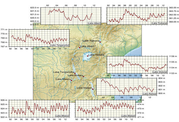
DGFI contributes to this project by retrieving higher-accuracy time series of water table elevation of large lakes and wetlands from stallite altimetry, using improved retracking and various satellite missions. Furthermore, time series of surface water area and water storage of the water bodies shall be retireved. To understand the dynamic water balance, the consistent time series of water elevation, area and storage will be combined with hydrological modelling through model validation or calibration by the project partners.

The project covers the time period 1993-2011 and focuses on six study areas, three large lakes with small variations in surface water extent, and three large seasonal wetlands:

  • Lake Tanganyika
  • Lake Turkana
  • Lake Constance
  • Tonle Sap and surrounding floodplains
  • Sudd Swamps
  • Pantanal
Time series of water table elevations from multi-mission satellite altimetry for various lakes in East Africa.

Selected Publications

Boergens E., Buhl S., Dettmering D., Klüppelberg C., Seitz F.: Combination of multi-mission altimetry data along the Mekong River with spatio-temporal kriging. Journal of Geodesy, 91(5), 519-534, 10.1007/s00190-016-0980-z, 2017
Boergens E., Nielsen K., Andersen O., Dettmering D., Seitz F.: River Levels Derived with CryoSat-2 SAR Data Classification-A Case Study in the Mekong River Basin. Remote Sensing, 9(9), 1238, 10.3390/rs9121238, 2017 (Open Access)
Boergens E., Buhl S., Dettmering D., Schwatke C., Seitz F.: The kriging method for combining multi-mission altimetry over the Mekong river. In: Ouwehand L. (Ed.) Proceedings of the Living Planet Symposium 2016, Prague, Czech Republic, ESA SP-740, 2016
Boergens E., Dettmering D., Schwatke C., Seitz F.: Treating the hooking effect in satellite altimetry data: a case study along the Mekong River and its tributaries. Remote Sensing, 8(2), 91, 10.3390/rs8020091, 2016 (Open Access)
Dettmering D., Schwatke C., Boergens E., Seitz F.: Potential of ENVISAT radar altimetry for water level monitoring in the Pantanal wetland. Remote Sensing, 8(7), 596, 10.3390/rs8070596, 2016 (Open Access)
Dettmering D., Strehl F., Schwatke C., Seitz F.: Satellite altimetry and SAR remote sensing for monitoring inundation in the Pantanal wetland. In: Ouwehand L. (Ed.) Proceedings of the Living Planet Symposium 2016, Prague, Czech Republic, ESA SP-740, 2016
Göttl F., Dettmering D., Müller F.L., Schwatke C.: Lake level estimation based on CryoSat-2 SAR altimetry and multi-looked waveform classification. Remote Sensing, 8(11), 885, 10.3390/rs8110885, 2016 (Open Access)
Schwatke C., Dettmering D., Bosch W., Seitz F.: DAHITI – an innovative approach for estimating water level time series over inland waters using multi-mission satellite altimetry. Hydrology and Earth System Sciences 19(10): 4345-4364, 10.5194/hess-19-4345-2015, 2015 (Open Access)
Schwatke C., Dettmering D., Boergens E., Bosch W.: Potential of SARAL/AltiKa for inland water applications. Marine Geodesy 38(Supplement 1): 626-643, 10.1080/01490419.2015.1008710, 2015
Singh A., Kumar U., Seitz F.: Remote sensing of storage fluctuations of poorly gauged reservoirs and state space model (SSM)-based estimation. Remote Sensing 7(12): 17113-17134, 10.3390/rs71215872, 2015 (Open Access)

Find more topics on the central web site of the Technical University of Munich: www.tum.de