Determination of Regional Gravity Fields
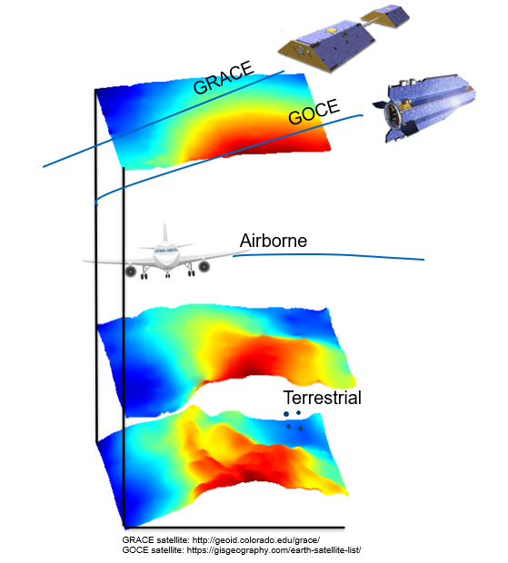
Gravity field determination supports applications from Earth system sciences, orbit determination, and the realization of physical height systems. Satellite gravity missions such as the Gravity Recovery and Climate Experiment (GRACE), GRACE-FO (Follow-On), and the Gravity field and steady-state Ocean Circulation Explorer (GOCE) are the main data sources for global gravity field modeling. However, their main limitation is the spatial resolution, since they lack information about spatial wavelengths below 100 km. Regional gravity measurements, In contrast, such as airborne, shipborne, or terrestrial gravity observations can provide a much higher spatial resolution of a few kilometers and can be combined with the satellite data for regional gravity field refinement (Figure).
The optimal combination of different types of gravity observations with varying spatial and spectral resolution is the key to obtain a high-precision regional gravity model. The global gravity field is usually mathematically described by spherical harmonic basis functions (SHs) as they fulfill the Laplacian differential equation and are orthogonal basis functions on a sphere. However, SHs cannot represent data of heterogeneous density and quality in a proper way. Different regional gravity field modeling methods can be applied instead, including the spherical radial basis functions (SRBFs) that have been further developed at DGFI-TUM over the last two decades. SRBFs can be used appropriately to consider the heterogeneity of different data types, thanks to their localizing features.
To further consider the spectral sensitivity of different observation techniques, a spectral combination based on SRBFs can be set up through the multi-resolution representation (MRR). The fundamental idea of the MRR is to split a gravity signal into a smoothed version for the long-wavelength part, and a number of detail signals in terms of wavelet functions for the medium and high frequency parts. Furthermore, the different resolution levels can be connected by the pyramid algorithm. Different types of observations can then be introduced into the estimation model at the level of their highest sensitivities, which makes it possible to benefit from the individual strengths of each data set optimally.
An essential geodetic application of the regional gravity field modeling is the realization of the International Height Reference System (IHRS), which is closely linked to DGFI-TUM’s research task Global Vertical Reference System. An experiment initiated by the IAG (1 cm Geoid Experiment) compared different methodologies for the computation of geoid heights, height anomalies, and geopotential values (as IHRS coordinates) based on the combination of gravity data from different sources. DGFI-TUM’s solution showed the smallest misfit of height anomaly and geoid height results at the benchmarks with respect to the mean values of all fourteen participants.
Related project
Selected Publications
 (Open Access)
(Open Access)
(Open Access)
(Open Access)
(Open Access)
Arcisstraße 21
80333 München