Regional Terrestrial Reference Frames
Regional densifications of the ITRF (i.e. EUREF in Europe, SIRGAS in Latin America, etc.) are necessary to provide a reliable accessibility to the global reference frame and to support the appropriate use of positioning and navigation techniques. The main objective of these regional densifications is to guarantee the consistency between terrestrial reference station positions and satellite orbits, which have to be determined in the same reference frame in order to exploit the high-precision of the measurements. Special care has to be given to the datum realization and the assimilation of seismic effects.
Today, the reference frames are a set of fiducial stations with known epoch positions, which are transformed to other epochs by applying constant velocities, i.e. linear coordinate changes over time. Nevertheless, station positions show seasonal variations resulting predominantly from atmospheric, oceanic or hydrological loading. Ignoring these seasonal variations and other non-linear movements may introduce large errors in the datum realization, and the reference networks can be significantly deformed. These effects are larger in regional networks than in global ones.
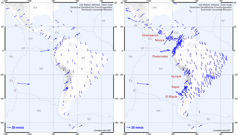
In addition, regional reference frames in seismic active areas are in particular exposed to large surface deformations caused by strong earthquakes (e.g. Chile 2010). Such events may damage existing reference networks and disable their use. According to this, the main purposes of this topic are (a) to define the best strategy for the datum realization and observation combination within regional reference frames; (b) to improve the modelling and representation of their kinematics to ensure a suitable transformation of station positions between pre- and post-seismic frame realizations; (c) to assess non-linear station movements within the reference frame computation to improve the estimation of epoch coordinates.
Related data products
- Geocentric Reference System for the Americas: SIRGAS reference frame realization
- Continuous SIRGAS surface kinematics model for Latin America and the Carribean: VEMOS
- SIRGAS weekly station positions
Selected Publications
 (Open Access)
Arcisstraße 21
80333 München