DGFI contributes to the implementation of an UN Resolution for a Global Geodetic Reference Frame
In February 2015, the UN General Assembly adopted its first geospatial resolution „A Global Geodetic Reference Frame for Sustainable Development“ [UN Resolution]. This resolution recognizes the importance of geodesy for many societal and economic benefit areas, including navigation and transport, construction and monitoring of infrastructure, process control, surveying and mapping, and the growing demand for precisely observing our planet's changes in space and time. The resolution stresses the significance of the global reference frame for accomplishing these tasks, for natural disaster management, and to provide reliable information for decision-makers.
The realization of global and regional terrestrial reference frames is among the core research activities of DGFI-TUM. In its role as ITRS Combination Center within the International Earth Rotation and Reference Systems Service (IERS) DGFI-TUM has taken the responsibility to regularly provide solutions for the International Terrestrial Reference Frame (ITRF). The ITRF is the fundamental Earth-fixed coordinate system of highest accuracy and long-term stability. It is the prerequisite for many areas of daily life (e.g., positioning, navigation, height systems, timing) and the backbone of Earth system research. DGFI's most recent solution of the ITRF is called DTRF2020.
The United Nations Global Geospatial Information Management (UN-GGIM) Working Group on the Global Geodetic Reference Frame (GGRF) [www.unggrf.org] has the task for drafting a roadmap for the enhancement of the GGRF under UN mandate.
The International Association of Geodesy (IAG), the scientific organization responsible for the field of geodesy, is preparing a document for the definition of the GGRF as realization of the Global Geodetic Reference System (GGRS), including a brief description of the key components. Based on its competence in the realization of reference frames DGFI-TUM is involved in this activity by contributing to the compilation of such a concept paper. The main purpose of this paper is to provide a common understanding for the definition of the GGRF and the scientific basis for the preparation of the roadmap to be accomplished by the UN-GGIM Working Group on the GGRF.
From the scientific IAG perspective a broad interpretation of the GGRF should be adopted to support the increasing demand for positioning, navigation and monitoring of global change phenomena in the Earth system. Thus, the GGRF is intended to include the terrestrial reference frame, the physical height and gravity reference frame as well as the celestial reference frame and the Earth orientation parameters. The geodetic observing systems, data centers, analysis centers as well as combination and product centers provide the basis for the GGRF. DGFI-TUM is strongly engaged in these international organisations and scientific services, and in many of them scientists of DGFI-TUM take leading roles.
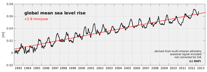
A prominent example for a global change phenomenon with a large impact on human populations living in coastal regions and on islands is the global sea level rise. In order to determine the rate of global sea level rise (around 2.9 mm/year) precisely and reliably over many decades, a highly-accurate and long-term stable geodetic reference frame is a fundamental requirement. The results displayed in Fig. 1 were computed by DGFI-TUM scientists using about 20 years of data from multi-mission satellite altimetry.
Arcisstraße 21
80333 München