Optimally combined regional geoid models for the realization of height systems in developing countries (ORG4Heights)
The main objective of ORG4Heights is the formulation of a general scientific concept for the realization and the establishment of height systems in countries with a low-quality terrestrial data basis, such as developing or newly industrializing countries, based on regionally enhanced gravity field models.
The definition of physical height systems is an essential geodetic application of the gravity field. For both scientific and practical reasons it is desirable to have global height systems consistent at the level of a few centimeters or better. However, many developing and newly industrializing countries are lacking any vertical reference system at all, which causes major negative consequences for construction, infrastructure, and the potential for industrialization. The general case for the realization of height reference systems is the combination of the Global Navigation Satellite Systems (GNSS) positioning, which can reach an accuracy of few millimeters, with a (quasi-) geoid model from gravity field modeling. Therefore, a high-resolution and high-precision geoid model is the key for the realization of height systems.
The main goal of ORG4Heights is addressed by the following tasks:
- The optimal combination of heterogeneous gravity observations using the method of spherical radial basis functions (SRBFs), further developed at DGFI-TUM in the last two decades. The methodical settings of the SRBFs, such as the type, bandwidth, and location of the SRBFs are studied. Within a parameter estimation process, various types of gravity data can be combined, and regularization is in most cases inevitable. Different regularization methods are compared, and the impact of the regularization parameter on the modeling results is investigated.
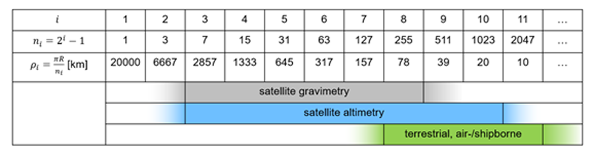
- The spectral combination of different data sets through a multi-resolution representation (MRR). As shown in Fig. 1, gravity data obtained from different observation techniques have varying spectral sensitivities. The high-resolution regional data (terrestrial, airborne, or shipborne) can be combined with the medium-resolution satellite altimetry measurements, and the low-resolution satellite gravimetry data (e.g., from the GRACE(-FO) and GOCE missions) through the MRR, so that each observation technique can contribute to the final model with maximum gravity information.
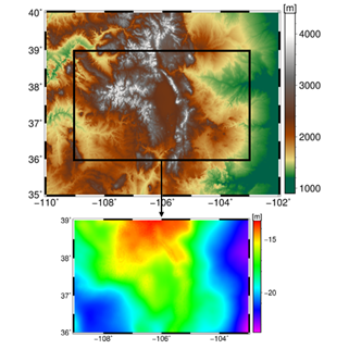
- The establishment of height systems, and the evaluation of achievable accuracies. As an example, Fig. 2 shows the computed geoid model for a case study in Colorado (“1 cm Geoid Experiment”). Based on the results of the case studies and several test scenarios, a generalized scientific concept towards an optimal regional gravity solution and correspondingly the establishment or improvement of a physical height system and its integration into a global vertical reference frame shall be derived. This generalized concept can then be used as guideline for further use in science and administration.
Selected Publications
 (Open Access)
(Open Access)
(Open Access)
(Open Access)
(Open Access)
Arcisstraße 21
80333 München