Geophysical application of gravity field information
The geophysical application of gravity field information is studied in close collaboration with external partners. Two main questions are to be answered:
- In what way does high-resolution gravity field information contribute to geophysical modeling?
- Are time-variable changes in the Earth's gravity field visible in the GOCE gravity gradients?
Based on the results achieved with regional gravity field modeling (RegGrav), especially those obtained with GOCE data, regional gravity field data are to be combined with geophysical data (e.g. seismics, magnetics) and models. The goal is to improve lithospheric and asthenospheric modeling, and to analyze in a common approach all data and models for geophysical exploration purposes. The added value of gravity field information in general and of GOCE data in particular is to be investigated and quantified.
Selected Publications
Bouman J., Ebbing J., Fuchs M., Sebera J., Lieb V., Szwillus W., Haagmans R., Novak P.: Satellite gravity gradient grids for geophysics. Nature Scientific Reports, 6, 21050, 10.1038/srep21050, 2016
 (Open Access)
(Open Access)
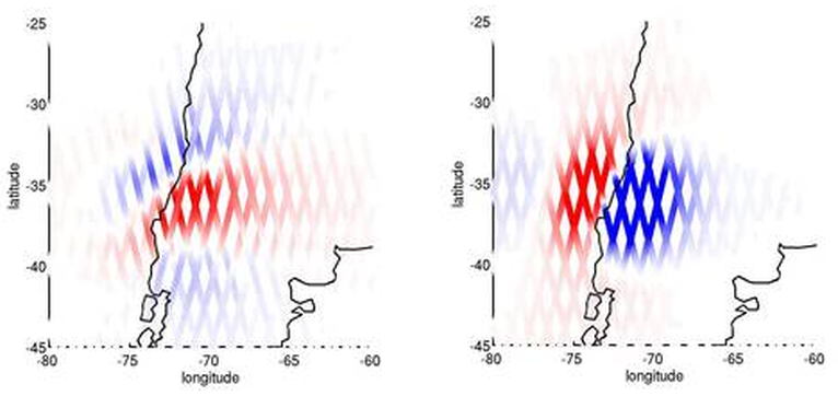
Fuchs M.J., Hooper A., Broerse T., Bouman J.: Distributed fault slip model for the 2011 Tohoku-Oki earthquake from GNSS and GRACE/GOCE satellite gravimetry. Journal of Geophysical Research, 121(2), 1114-1130, 10.1002/2015JB012165, 2016
Greff-Lefftz M., Métivier L., Panet I., Caron L., Pajot-Métivier G., Bouman J.: Joint analysis of GOCE gravity gradients data of gravitational potential and of gravity with seismological and geodynamic observations to infer mantle properties. Geophysical Journal International, 205(1), 257-283, 10.1093/gji/ggw002, 2016
Deutsches Geodätisches Forschungsinstitut
Prof. Dr.-Ing. habil. Florian Seitz
Technische Universität München
Arcisstraße 21
80333 München
Arcisstraße 21
80333 München