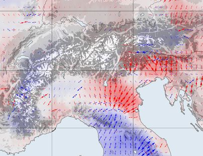
The Alps in motion

The Alps are on the go: The mountain range drifts northwards an average of one-half millimeter every year and rises 1.8 millimeters. This is the result of a recent study for which scientists of DGFI-TUM analyzed 12 years of measurements from more than 300 GPS stations distributed over the entire chain of the Alps and its foreland. The scientists identified the positions of the GPS stations, accurate down to fractions of a millimeter. A large number of the stations were set up in the EU project ALPS-GPSQUAKENET and are in part operated by DGFI-TUM itself.
The greatest challenge was the homogeneous processing of one-half million observed data items. The measurements are impaired by several interference factors, e.g. atmospheric signal delay, that have to be detected and corrected. The study used the corrected measured values to create a computer model that illustrates horizontal and vertical shifts as well as lateral spreading and compression over the entire Alpine region at a resolution of 25 kilometers.
The model depicts visibly both large-scale patterns of movement and regional special factors: For example each year the Alps grow an average of 1.8 millimeters in height and move to the northeast at a speed of up to 1.3 millimeters. In South and East Tyrol however a rotation towards the east is superimposed on this movement, while at the same time the mountain range is being compressed. And the rise in height is not identical everywhere either: Very small in the southern part of the western Alps, it reaches its maximum with a speed of more than 2 millimeters per year in the central Alps, at the boundaries of Austria, Switzerland and Italy. These changes in the surface of the earth serve as the basis for inferences regarding underground plate tectonics. The research was conducted in collaboration with the Geodesy and Glaciology project of the Bavarian Academy of Sciences and Humanities. Details on the data processing and the results of the study are presented in the open-access publication Present-day surface deformation of the Alpine Region inferred from geodetic techniques (Earth System Science Data, 2018, DOI: 10.5194/essd-10-1503-2018).
Arcisstraße 21
80333 München