Regional high-resolution ionosphere maps for continental regions
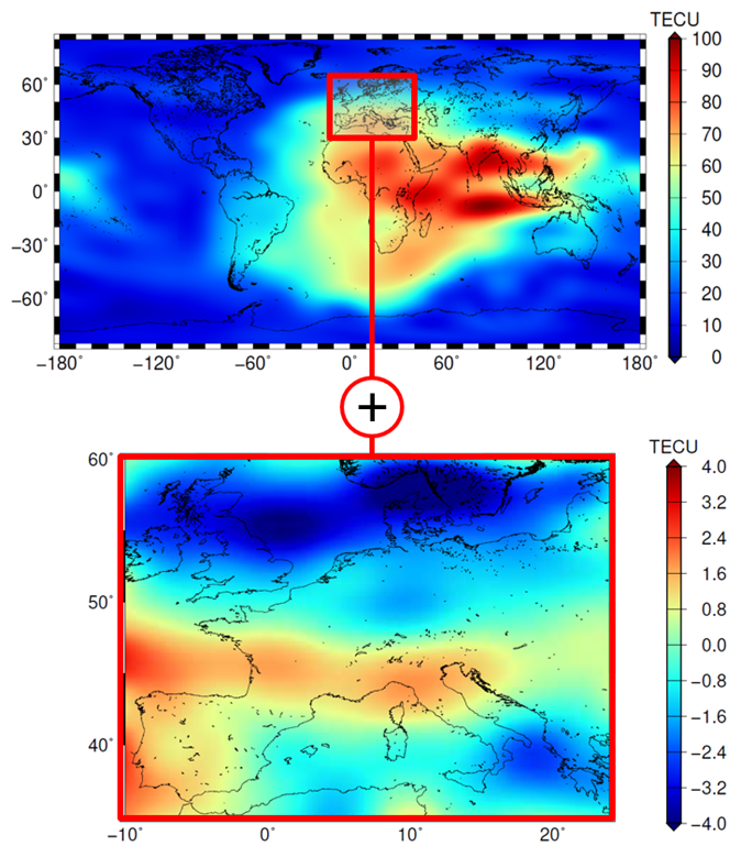
Ionospheric signal delay is one of the largest error sources in GNSS (Global Navigation Satellite Systems) applications and can cause positioning errors in the order of several meters. Especially for single-frequency users, who cannot correct for ionospheric signal delay, external information about the state of the ionosphere is essential. The International GNSS Service (IGS) and its Ionosphere Associated Analysis Centers (IAAC) routinely provide this information in terms of global ionosphere maps (GIM) representing the Vertical Total Electron Content (VTEC). The GIMs are typically limited in their spatial and spectral resolution (spherical harmonic degree 15) caused by the globally inhomogeneous distribution of GNSS observations used for GIM generation. Regional GNSS networks, however, offer dense clusters of observations, which can be used to generate regional VTEC solutions with a higher spectral resolution.
Based on a two-step approach which comprises a global model and a regional densification, scientists of DGFI-TUM have developed an algorithm to generate regional VTEC maps with higher spectral resolution accounting for the finer signal structures. The algorithm is integrated in a software package to provide VTEC maps using hourly GNSS data and ultra-rapid orbits. It allows for the dissemination of VTEC maps with a latency of 2 to 3 hours.
A numerical study for March 2015 based on hourly GNSS data provided by the IGS and the EUREF network is presented in the article Global and Regional High-Resolution VTEC Modelling Using a Two-Step B-Spline Approach (Remote Sensing, 2020, doi:10.3390/rs12071198, [PDF]). Validation with independent data shows that the generated regional high-resolution VTEC maps are of comparable accuracy to the regional maps provided by the Royal Observatory of Belgium, currently being the best known publicly available product for Europe. While the latter is provided with a latency of about one week, DGFI-TUM’s VTEC maps are characterized by low latency allowing for high precision positioning and navigation.
Arcisstraße 21
80333 München