Improving the precision of sea level data
Precise information on sea level changes is required for various questions of societal, economic and scientific relevance. DGFI-TUM researchers have produced a new correction to sea level data measured from space which improves their precision by about 30%.
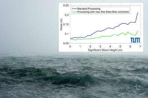
Since more than two decades scientists use radar antennas (altimeters) installed on satellites orbiting around the Earth. The altimeters send a pulse of energy that expands onto an area of the ocean surface that can be several kilometers wide. The illuminated area is influenced by wind and waves (so-called sea state), that interact with the radar signal sent by the satellite. Moreover, the algorithms used to analyse the reflection from the ocean surfaces estimate sea level, waves and wind at the same time, causing interconnections between the estimation errors. This generates the need of a correction to the measured sea level, called Sea State Bias.
A recent study demonstrates a strong improvement in the precision of sea level data by estimating a new sea state bias correction. The innovative approach applies a data correction to measurements recorded every 300 m ("high-frequency” measurements), while in the past this correction was generated for 7 km averages (“low-frequency"). The study focused on two oceanic regions: the North Sea and the Mediterranean Sea. In order to verify the new correction, sea level measurements from nearby locations were compared against each other. It was shown that the noise of the high-frequency measurements is lower by 30%: While sea level anomalies (i.e. deviations of the sea level from a mean state that are typically up to 2 m) could previously be measured with a precision of 8 cm, this can be now done with a precision of less than 6 cm. This is very valuable in particular for oceanographic applications, such as for example the study of ocean currents, whose determination is strongly affected by the noise in the data provided by satellites.
The study was partially funded by the European Space Agency’s Sea Level Climate Change Initiative and is presented in the publication Improving the precision of sea level data from satellite altimetry with high-frequency and regional sea state bias corrections (Remote Sensing of Environment, 2018, DOI: 10.1016/j.rse.2018.09.007).
Arcisstraße 21
80333 München