Time-variable surface areas of lakes and reservoirs monitored from space
Continuous monitoring of lakes, rivers and reservoirs is of great importance for various hydrological, societal and economic questions. In many regions, hydrological parameters of inland water bodies, such as water level, surface extent, volume and discharge and their temporal changes are directly related to security-relevant aspects. Among those are water supply, water management and the protection of population and infrastructure, in particular in the view of global change, where the growth of population and more frequent extreme weather situations pose various challenges. The availability of up-to-date observation data is essential for the measurement of flooded regions and for the quantification of water storage in lakes and reservoirs.
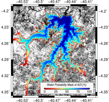
Scientists of DGFI-TUM developed a new approach for the automated extraction of high-resolution time-variable water surface masks of lakes and reservoirs from optical satellite images, using observations from Landsat and Sentinel-2 between 1984 and 2018. The algorithm first extracts land-water masks from the images by combining five different water indices and applying an automated threshold computation. These monthly masks are used to compute a long-term water probability mask, which is then applied to fill data gaps caused by voids, clouds, cloud shadows or snow. Iteratively, all data gaps in all monthly masks are filled, which leads to a gap-free surface area time series. The resulting surface area changes were compared with water level time series from gauging stations, or, if in-situ data was not available, water level time series from satellite altimetry. Overall, 32 globally distributed lakes and reservoirs of different extents up to 2480 km² were investigated. Filling of the data gaps improved the average correlation coefficients between the time series of surface area and water levels from 0.61 to 0.86. This means an improvement of 41%. A cross-validation showed RMS errors smaller than 40 km² for all study areas, corresponding to relative errors below 8%. This demonstrates the strong impact of a reliable gap-filling approach and the quality enhancement of the land-water masks resulting from the new algorithm. Details are provided in the publication Automated Extraction of Consistent Time-Variable Water Surfaces of Lakes and Reservoirs Based on Landsat and Sentinel-2 (Remote Sensing, 2019, DOI: 10.3390/rs11091010, [PDF]). All presented surface area time series are freely available via DGFI-TUM’s Database of Hydrological Time Series of Inland (DAHITI).
Arcisstraße 21
80333 München