River levels tracked from space
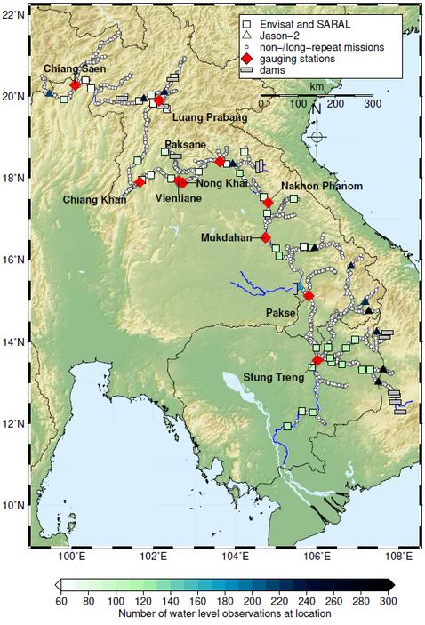
The 4,300 kilometer Mekong River is a lifeline for South-East Asia. If this mighty river system bursts its banks, flooding can affect the lives and livelihoods of millions of people. Permanent monitoring of the river's water stage is thus essential. Using the example of the Mekong river with its pronounced changes in water level, an innovative method to monitor complex river basins solely based on satellite data has been developed in collaboration between TUM scientists from geodesy and mathematics. The approach allows for modelling how water levels are impacted on various sections of the river by extreme weather events such as heavy rainfall or drought over extended periods.
The approach uses measurement data collected from various altimetry satellite missions. In a first step, their raw observations are analysed applying specially developed retracking algorithms in order to create precise time series of water levels for the crossing points of the satellites' tracks with the river. Altimetry satellites on repetitive orbits usually pass over the same points on a repeating cycle of 10 to 35 days. As a result, water level data are captured for each of these points at regular intervals. But the study also integrates observations collected by Cryosat-2, a SAR altimetry satellite on a long-repeat orbit. The SAR altimetry method is superior to conventional systems in terms of accuracy, and the long-repeat orbit results in a very dense spatial resolution of the observations. But at the same time, the temporal resolution of Cryosat-2 data is very low. Thus, the points observed by Cryosat-2 are well distributed throughout the entire river system, but each of the points is only measured once or twice.
The flow patterns of the river, with its complex network of tributaries, are modelled using the statistical method known as universal kriging. The model allows for linking satellite data from different altimetry missions, including Cryosat-2, and makes it possible to extrapolate water levels observed at certain points to determine the levels at almost any location in the entire river system. It was demonstrated that including the precise and densely distributed SAR measurements in the model greatly improved the quality of the results. Details on the study including data processing and results are presented in the publication Observing water level extremes in the Mekong River Basin: The benefit of long-repeat orbit missions in a multi-mission satellite altimetry approach (Journal of Hydrology, 2019, DOI: 10.1016/j.jhydrol.2018.12.041).
Arcisstraße 21
80333 München