Refined estimates of absolute water levels for inland waters from multi-mission satellite altimetry (WALESA)

Continental water transport and storage control the distribution of freshwater resources and affect atmospheric processes, sea level, and global biogeochemical cycles. The central objective of the DFG Research Unit (RU) GlobalCDA is to improve our understanding of global freshwater resources and to obtain better estimates of continental water fluxes (streamflow, groundwater recharge, actual evapotranspiration, and renewable water resources) and storages (in snow, soil, groundwater and surface water bodies as well as in glaciers). This will be reached through combining state-of-the art hydrological modelling with geodetic and remote sensing data in an innovative ensemble-based calibration and data assimilation approach.
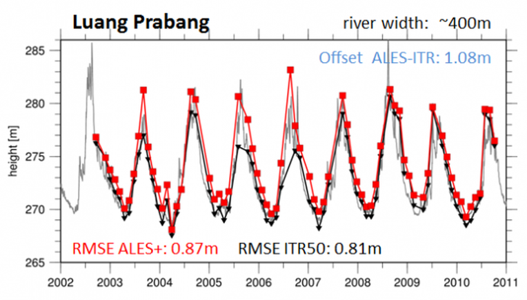
Within the RU GlobalCDA, the project WALESA will provide a comprehensive set of water table elevation time series of all major inland water bodies. This data set is the foundation for the computation of water volumes as well as river discharges that will be used for the calibration and assimilation into the WaterGAP model. Besides providing the necessary data basis for training regions as well as for validation and critical regions, the project will focus on the development of new methods and approaches necessary to ensure the automated and fast derivation of reliable data at highest accuracy for all major water bodies on a global scale. In detail, within the project the following methodologies will be developed:
- Automated target detection of permanent and non-permanent water bodies,
- Reliable waveform classification applicable for different surface types (especially for different large and small open water bodies) and consistent for all missions,
- Refined inland retracking algorithm for inland altimeter data allowing for a consistent multi-mission data combination, and
- Reliable uncertainty estimation for each estimated water level. All methods developed will be carefully evaluated and compared to existing methods and results as well as to independent datasets if available.
This project is funded by the German Research Foundation (DFG) within the framework of the research unit GlobalCDA on „Understanding the global freshwater system by combining geodetic and remote sensing information with modelling using a calibration/data assimilation (CDA) approach“ (RU 2630). The work is done in cooperation with Goethe University Frankfurt, University of Bonn, GFZ Potsdam, Hafencity University Hamburg, University of Stuttgart, DLR Oberpfaffenhofen, Univeristy of Zürich, University of Luxembourg

Selected Publications
 (Open Access)
 (Open Access)
Arcisstraße 21
80333 München