DGFI-TUM releases a new realization of the International Terrestrial Reference System: DTRF2014
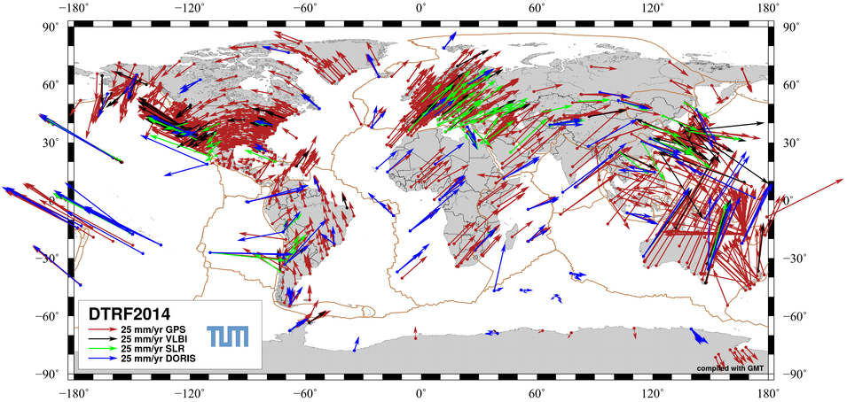
The DTRF2014 is DGFI-TUM’s new realization of the International Terrestrial Reference System (ITRS). It comprises positions and velocities of 1712 globally distributed stations of the space geodetic observation techniques VLBI, SLR, GNSS and DORIS as well as consistently estimated Earth orientation parameters. The DTRF2014 includes six additional years of data compared to the previous realization, i.e., the DTRF2008 (Seitz et al., 2012). Additionally, for the first time, non-tidal atmospheric and hydrological loading is considered in the DTRF2014.
In its role as an "ITRS Combination Centre" within the International Earth Rotation and Reference Systems Service (IERS), DGFI-TUM took the responsibility for providing realizations of the ITRS in regular intervals. An up-to-date ITRS realization at highest accuracy and long-term stability is an indispensable requirement for various applications in daily life (e.g., for navigation and positioning, for the realization of height systems and precise time systems or for the computation of spacecraft and satellite orbits). Furthermore, it is the backbone for Earth system research by providing the metrological basis and uniform reference for monitoring processes in the context of global change (e.g., ice melting, sea level rise). Read more about the DTRF2014 here (also available in German here).
The DTRF2014 is available for download in our Science Data Products section.
Arcisstraße 21
80333 München