High-resolution river water levels based on multi-mission altimetry data
Classical approaches of inland altimetry determine water level variations of rivers at so-called virtual stations, i.e. fixed locations given by the crossings of altimeter tracks and rivers. Depending on the repeat cycles of the individual altimeter missions, the temporal resolution of these time series is limited to 35 or 10 days.
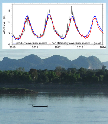
Now, scientists of DGFI-TUM have developed a method to provide a complete spatio-temporal description of the Mekong River based on multi-mission altimetry data. Details and results are described in the article Combination of Multi-Mission Altimetry Data Along the Mekong River with Spatio-Temporal Kriging (Journal of Geodesy, 2016, DOI: 10.1007/s00190-016-0980-z). The approach uses statistical robust interpolation to combine measurements of different altimetry missions, considering diverse flow velocities of the river as well as remote relationships between different catchment areas. With this approach, water level time series can be determined for arbitrary locations along the river at a significantly increased temporal resolution. For the test case of the Mekong, a resolution of 5 days could be achieved. The accuracy was improved by 23 to 34% compared to standard methods.
Arcisstraße 21
80333 München