Resolving water level changes of small rivers with CryoSat-2 SAR altimetry
CryoSat-2, launched in 2010, is the first altimetry satellite partly operating in synthetic-aperture radar (SAR) mode. Compared to conventional radar altimeters, the SAR mode enables altimetry measurements at increased along-track resolution and with smaller footprint. This opens new possibilities for the determination of water levels also of smaller inland water bodies that could not reliably be observed by the classical altimetry satellites. With its repeat time of 369 days CryoSat-2 does not provide a good temporal resolution, but on the other hand this long repeat orbit configuration results in a very dense spatial sampling of the water level, e.g. along a river.
The first step in the calculation of the water levels from CryoSat-2 data is the classification of the recorded radar returns into signals from water and land surfaces. Usually the classification is based on a predefined land-water mask. Such masks are often invariant with respect to time, i.e. they neither account for seasonal variations of the water extent nor for inter-annually shifting river banks. The determination of dynamic land-water (e.g. from remote sensing images) is difficult in particular in regions with frequent cloud coverage, and usually satellite images are not available simultaneously with the altimetry measurements.
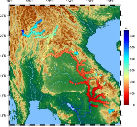
By example of the Mekong river basin, scientists of DGFI-TUM and DTU Space (Denmark) developed and validated a new method for the identification of water returns in CryoSat-2 data that is independent from a land-water mask and relies solely on features derived from the SAR and range-integrated power (RIP) waveforms. The new approach has proven its effectiveness especially in the upstream region of the basin that is characterized by small- and medium-sized rivers. Compared to an approach based on a land-water mask, the new method significantly increased the number of valid measurements and their precision (1700 with 2% outliers vs. 1500 with 7% outliers). The approach and results are described in the open-access publication River Levels Derived with CryoSat-2 SAR Data Classification - A Case Study in the Mekong River Basin (Remote Sensing, 2017, DOI:10.3390/rs9121238, [PDF]).
Arcisstraße 21
80333 München