Innovative processing of altimetry data allows for monitoring water levels in wetlands
Over the last years satellite altimetry has proven its potential to monitor water level variations not only over the oceans but also over inland water bodies. DGFI-TUM provides altimetry-derived time series of water stage variations of various globally distributed rivers and lakes via its web service "Database for Hydrological Time Series over Inland Waters" (DAHITI).
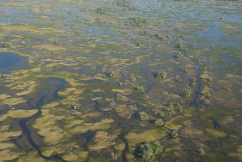
Now, scientists of DGFI-TUM have developed an innovative processing method for monitoring and analyzing water level variations in wetlands and flooded areas. The approach is based on automated altimeter data selection by waveform classification and an optimized waveform retracking. It is described in the article Potential of ENVISAT Radar Altimetry for Water Level Monitoring in the Pantanal Wetland (Remote Sensing, 2016, available via open-access).
Using the example of the Pantanal wetland in South America, this study demonstrates the capability and limitations of the ENVISAT radar altimeter for monitoring water levels in inundation areas. The accuracy of water stages varies between 30 and 50 cm (RMSE) and is in the same order of magnitude as reported for smaller rivers. Most areas of the Pantanal show clear annual water level variations with maximum water stages between January and June. The amplitudes can reach up to about 1.5 m for larger rivers and their floodplains. However, some areas of the wetland show water level variations of less than a few decimeters, which is below the accuracy of the method. These areas cannot reliably be monitored by ENVISAT. Further investigations will show if the usage of Delay-Doppler altimeter data (such as measured by the recently launched Sentinel-3 mission) might improve the results there.
Arcisstraße 21
80333 München