Advances in Remote sensing of Inland waters by Satellite Altimetry with special focus on SWOT (ARISAS)

The DFG project ARISAS comprises the contribution of DGFI-TUM to the second phase of the interdisciplinary DFG Research Unit (RU) GlobalCDA on „Understanding the global freshwater system by combining geodetic and remote sensing information with modelling using a calibration/data assimilation (CDA) approach“ (RU 2630). GlobalCDA involves scientists from seven German and three European institutions.
The overall goal of the RU is to improve our understanding of global freshwater resources and to obtain better estimates of continental water fluxes (streamflow, groundwater recharge, actual evapotranspiration, and renewable water resources) and water storages (in snow, soil, groundwater, and surface water bodies as well as in glaciers). The second phase of GlobalCDA focuses on the transfer of the calibration and data assimilation (CDA) approach, combining hydrological modelling with geodetic and remote sensing data as developed in the first phase, to a global application.
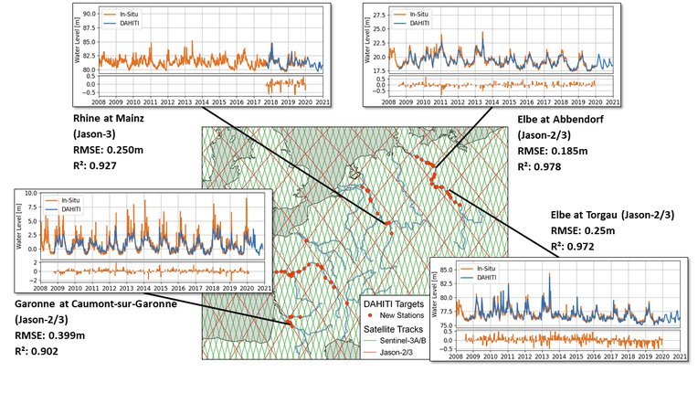
DGFI-TUM's task within the RU is to create and provide water level time series of all major inland water bodies measured by satellite altimetry. These time series are essential to compute changes of lake water storage and river discharge, the quantities that are required for the calibration and assimilation into the WaterGAP global hydrological model. Furthermore, the project will continue the work on an improved retracking algorithms and uncertainty estimation started within project WALESA.
The objectives of ARISAS are the exploitation of data from new altimetry missions and measurement techniques, especially the Sentinel-6 observations in interleaved SAR mode, ICESat-2 laser measurements, and SWOT wide swath altimetry.
The integration of these new data will significantly increase the spatial and temporal resolution of water level time series that can be derived in the context of GlobalCDA and will be essential for reaching the target of a global application. Additionally, the new measurements will improve the accuracy of water level estimates in comparison with the application of classical pulse based altimeters.
As a result, the project will provide globally distributed water level time series for up to 30 years together with uncertainty estimates, based on various satellite altimetry missions with different sensors and at highest possible accuracy.
Selected Publications
 (Open Access)
Arcisstraße 21
80333 München