Circulation from In-situ and Remote-sensing data in COastal and Shelf ocean (CIRCOS)
Ocean circulation is a key player in regulating the Earth's climate. It connects the sea surface with deeper layers of the ocean and enables the storage and transport of heat, salt and carbon. To be able to predict the development of the climate, it is essential to detect changes in the circulation through observations. Furthermore, changes in ocean circulation, especially in the coastal zone, are relevant for disaster management, coastal engineering and management, and the use of marine resources. This relevance motivates the development of novel strategies to improve circulation datasets based on satellite altimetry near the shores.
CIRCOS aims at generating improved ocean circulation data in coastal and shelf regions. To achieve this goal, a novel methodology is being developed to improve gridded circulation data sets based on satellite altimetry, incorporating wind measurements. This information on coastal currents will contribute to a better understanding of the underlying processes and form the basis for predicting climate impacts.
The project objective is to be achieved by improving the high frequency content of the existing gridded sea level data. For this purpose, firstly, the grid data will be blended with along-track data obtained by a specific coastal reprocessing of the altimetry signals. Secondly, satellite altimetry sea level observations will be statistically combined with complementary information, such as wind stress, to improve temporal and spatial resolution. Finally, the use of modern interpolation methods will be explored to improve the ability to preserve fine scales of variability.
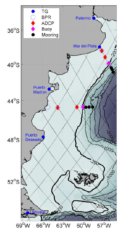
For the CIRCOS study area, the Argentinean Continental Shelf (ACS), high-resolution maps of sea surface anomalies will be generated for the years starting from the launch of Sentinel-3A (February 2016). The new data set and derived geostrophic current velocities will be used to describe coastal sea level variability and circulation associated with external climate forcing. The California Current System (CCS) will be used as a second verification area to benefit from the dense in-situ tide gauge network there and to explore how the methodology of this project can be generalised to other coastal areas. A collaboration with the University of Buenos Aires (Argentina) and the Scripps Institution of Oceanography (USA) will help validate and interpret the results in the two regions.
Arcisstraße 21
80333 München