The availability and accessibility of freshwater on Earth is an issue of growing relevance. Various related applications, such as water resource management and civil protection, rely on accurate water storage information. Against the background of declining ground-based measurements, remote sensing techniques are becoming increasingly important for monitoring lakes and reservoirs worldwide.
DGFI-TUM is working on methods to optimally combine water level information from satellite altimetry with additional remote sensing information to derive accurate time series of storage changes of lakes and reservoirs. Besides, the data is used to compute further parameters, such as lake bathymetry.
Temporal evolutions in surface extent and probabilities of water cover are obtained primarily from Landsat and Sentinel-2 optical satellite imagery. The relationship between surface extent and water level (hypsometric curve) determined for a water body can furthermore be used as a proxy to extend water level information back in time to the early 1980s.
Data are made available through the web service DAHITI (Database for Hydrological Time Series of Inland Waters).
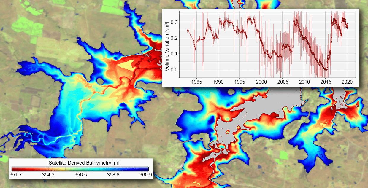
Time series of volume variations and derived bathymetry for Hubbard Creek, Reservoir (10272) located in Texas.
Selected Publications
Deggim S., Eicker A., Schawohl L., Gerdener H., Schulze K., Engels O., Kusche J., Saraswati A.T., van Dam T., Ellenbeck L., Dettmering D., Schwatke C., Mayr S., Klein I., Longuevergne L.: RECOG RL01: correcting GRACE total water storage estimates for global lakes/reservoirs and earthquakes. Earth System Science Data, 2227-2244, 10.5194/essd-13-2227-2021, 2021
(Open Access)
Herrnegger M., Stecher G., Schwatke C., Olang L.: Hydroclimatic analysis of rising water levels in the Great rift Valley Lakes of Kenya. Journal of Hydrology: Regional Studies, 36, 100857, 10.1016/j.ejrh.2021.100857, 2021
(Open Access)
Dettmering D., Ellenbeck L., Scherer D., Schwatke C., Niemann C.: Potential and Limitations of Satellite Altimetry Constellations for Monitoring Surface Water Storage Changes - A Case Study in the Mississippi Basin . Remote Sensing, 12(20), 3320, 10.3390/rs12203320, 2020
(Open Access)
Schwatke C., Dettmering D., Seitz F.: Volume Variations of Small Inland Water Bodies from a Combination of Satellite Altimetry and Optical Imagery. Remote Sensing, 12(10), 1606, 10.3390/rs12101606, 2020
(Open Access)
Schwatke C., Scherer D., Dettmering D.: Automated Extraction of Consistent Time-Variable Water Surfaces of Lakes and Reservoirs Based on Landsat and Sentinel-2. Remote Sensing, 11(9), 1010, 10.3390/rs11091010, 2019
(Open Access)
Busker T., de Roo A., Gelati E., Schwatke C., Adamovic M., Bisselink B., Pekel J.-F., Cottam A.: A global lake and reservoir volume analysis using a surface water dataset and satellite altimetry. Hydrology and Earth System Sciences, 23(2), 669-690, 10.5194/hess-23-669-2019, 2019
(Open Access)
Singh A., Seitz F., Eicker A., Güntner A.: Water budget analysis within the surrounding of prominent lakes and reservoirs from multi-sensor Earth observation data and hydrological models: case studies of the Aral Sea and Lake Mead. Remote Sensing, 8(11), 953, 10.3390/rs8110953, 2016
(Open Access)
Singh A., Kumar U., Seitz F.: Remote sensing of storage fluctuations of poorly gauged reservoirs and state space model (SSM)-based estimation. Remote Sensing 7(12): 17113-17134, 10.3390/rs71215872, 2015
(Open Access)
Deutsches Geodätisches Forschungsinstitut
Prof. Dr.-Ing. habil. Florian Seitz
Technische Universität München
Arcisstraße 21
80333 München
 (Open Access)